Call: (863) 333-4265      Email: [email protected]
Drone Elevations
  • Home
  • Services
    • Real Estate
    • Video Production
    • Imagery >
      • Real Estate
      • Land
      • Assisted Living Facilities
      • Hotels and Resorts
      • Vacation Rentals
      • Businesses
      • Storage Facilities
      • Churches
    • Drone Inspections >
      • Roof Inspection
      • Damage Inspections
      • Construction
      • Agriculture
      • Golf Courses >
        • Blog
    • Weddings
    • Drone Flight Training
    • Drone Pilot License
  • Examples
  • About
    • About Drone Elevations
    • Testimonials
    • FAQ
    • News & Info
    • Job Opportunities
  • Contact
  • Schedule Now

Aerial Agriculture Services

Schedule Now

If You Fail to Plan, You Plan to Fail.
​Plan on Saving Crops and Money with Our Drone Aerial Agriculture Services.

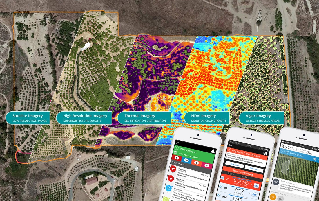
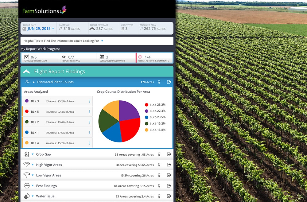
Through the use of drones, we take aerial scans of your farm so the grower can make their own informed growing decisions based upon our real time data. We transform aerial imagery into actionable data, allowing growers to lower costs and increase yields.
​

​What Can Be Identified 

  • Plant Stress
  • Pest Infestations
  • Nutrient Application Issues
  • Crop Health Assessment 
  • Crop Density & Counts 
  • Stages of Plant Growth 
  • Ranch Mapping
Schedule a Free demonstration now!
Picture

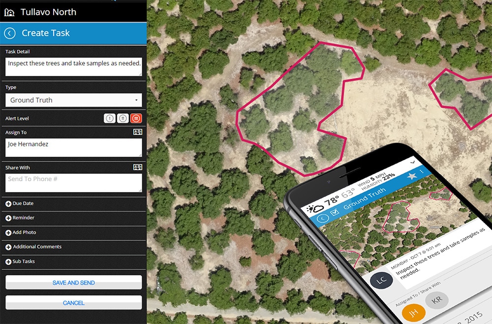
Taking Action with Aerial Imagery

  • Improve irrigation efficiency 
  • Optimize fertilization plans 
  • Forecast yields 
  • Identify plants to be culled 
  • Apply pesticides precisely 
  • Efficiently deploy labor 

How It Works

  1. Scout: Drone Elevations UAVs fly to count crops, identify crop stress, and forecast yields. 
  2. Detect: Review analyzed flight imagery with our experts, then share with your agronomist and staff. 
  3. Implement: Navigate directly to problem areas, ground-truth, and apply treatment as your team determines. 

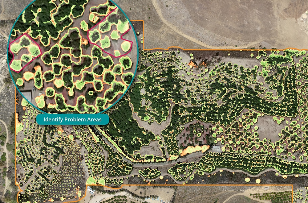
​Plant Vigor Assessment & Identification 

  • Quickly identify area of stress 
  • Ground-truth with your agronomist 
  • Convert agronomist diagnosis into an action plan 
Our vigor assessment isolates areas where vegetation is lacking, or experiencing some form of stress. Using this imagery growers can identify areas requiring action and create a treatment plan, resulting in reduced input costs and increased yields. 
Picture

​Transform Aerial Imagery into Action 

  • Pinpoint problem areas 
  • Assign tasks to staff, agronomists or PCA’s 
  • Monitor task progress 
Detect and treat early-onset crop issues by generating a series of tasks or action items. Once areas of interest have been identified, tasks can be assigned to agronomists, PCAs, or field staff to take action. Using our mobile tools they can navigate directly to the identified area with precision. 
Picture

​Flight Summary Reports 

  • Review flight findings 
  • Compare reports from multiple flights 
Review key findings and areas of interest in a comprehensive flight summary report. Compare reports from multiple flights to monitor progress and share improvements with landowners, lenders, insurance providers and more.  
Picture
Schedule a free demonstration now!

One Comprehensive Solution

Drone Elevations provides turnkey aerial image services, including all of the equipment, piloting, insurance and FAA approvals needed to fly safely and inexpensively. 

Using these analytical tools, task management and mobile capabilities, the grower, farm manager, and agronomist can easily extract actionable knowledge from aerial data. Focusing in facts that can be managed and tracked, the farm team can convert aerial imagery into low cost farm intelligence, saving money on nutrients, pesticides, and labor.

Show Others Your Pride with Our Aerial Videos!


Schedule Your Aerial Photos Now!
Picture
Drone Elevations is located at 502 East Main Street, Lakeland, FL 33801.
​
Phone: (863) 333-4265     |     Email: [email protected]

​Mon-Fri: 9:00a-5:00p (Check Availability)     |     Sat, Sun & Holidays: Limited Availability
​
Picture
Picture
Picture

Drone Elevations is affiliated with the following organizations:
Drone Elevations Affiliations
Picture
Click Here for special DJI Coupon Codes and discounts.

Subscribe To Our Newsletter
Active Client | Login to Service Account
Drone Elevations Membership Portal & Login

Please note: waivers and authorization might be required due to FAA airspace restrictions.
​All pricing and special offers are due to change without notice. travel fees could apply.

Registered with the FAA. All Pilots are Part 107 Certified. Licensed and Insured (General Liability for both ground and aerial). Preferred Business Partner of LAR. Member, Trained and Certified by Sky Eye Network the world's largest network of drone entrepreneurs. Proud member of PPA, DJI and AMA.
We adhere to the CDC Covid recommendations.
​
Copyright © 2016-2025 Drone Elevations, LLC | Privacy Policy | Terms & Conditions | Cancellation Policy | Site by NOVAK Brand.

Home | Services | Examples | Testimonials | FAQ | News & INFO | CONTACT | SITEMAP

Credit Cards Accepted
x

We are open thanksgiving FOR real estate photoshoots.

Please Note: A minimum $45 Holiday Fee applies for jobs captured on 11/24 and 11/25.
Picture
x

website is currently under maintEnAnce and not fully operational

Book Online
x

Temporary Flight Restrictions

PLEASE NOTE:
​There can be Temporary Flight Restrictions in place during Lakeland's Sun n Fun Airshows
Picture
Learn More
Picture
x

WE OFFER HURRICANE DAMAGE INSPECTION

Learn More
Picture
H
x

PRE-hurricane damage inspection

Be proactive this hurricane season and request a roof inspection prior to any possible damage. You will then receive 50% OFF on a post-hurricane inspection should any damage occur – FOR THE LIFE OF YOUR ROOF! We provide documentation to help you receive full insurance claim payouts. Roof, land, agriculture, commercial property, public facility, or golf course inspections - We've got you covered!
​
LEARN MORE
Picture
  • Home
  • Services
    • Real Estate
    • Video Production
    • Imagery >
      • Real Estate
      • Land
      • Assisted Living Facilities
      • Hotels and Resorts
      • Vacation Rentals
      • Businesses
      • Storage Facilities
      • Churches
    • Drone Inspections >
      • Roof Inspection
      • Damage Inspections
      • Construction
      • Agriculture
      • Golf Courses >
        • Blog
    • Weddings
    • Drone Flight Training
    • Drone Pilot License
  • Examples
  • About
    • About Drone Elevations
    • Testimonials
    • FAQ
    • News & Info
    • Job Opportunities
  • Contact
  • Schedule Now